
 |
Like our website?
'Like' us on Facebook... |
|
|
Have you found this site useful? If so,
why not make a small contribution to our running costs. Just click
on the button below for more details:
|
Walking in the Peak District, Derbyshire,
UK - Brassington and Carsington Pasture |
A short circular walk from Brassington, Derbyshire across Carsington Pasture.
Grade: |
Easy |
Distance: |
8km |
Altitude Gained: |
~250m |
Duration: |
2 hours |
Towards the South of the Peak District lies the large reservoir of
Carsington Water, and the villages of Brassington and Carsington.
This short circular walk starts from the village of Brassington, crossing
Carsington pasture. As it does so, you are rewarded with superb and
far-reaching views.
|
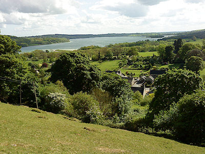
Above: Looking down on Carsington Water, Derbyshire.
© Mat & Niki Adlam-Stiles, 2010
|
Walk in brief:
An easy circular walk on clear trails with plenty of superb views.
Carsington Pasture is the site of many ancient lead mines, and there is an
abundance of archaeological interest. Sadly, the landowner is very
insistent that walkers stay on the footpaths!
There is minimal altitude to be gained, although the short section climbing out
from Carsington village is steep.
The walk starts in the village of Brassington, where on-street parking can
usually be found. Brassington has two good pubs, both offering food, but
no village shop.
Refer to the Ordnance Survey Map OL24 (White Peak) for more ideas/information.
|
|
|
|
|
Starting from Brassington:
Near the road junction (SK232543) a public footpath heads East, intially
through a yard/access track, before swinging right into open countryside.
A clear path crosses two fiedls, climbing gently, before heading
directly uphill to a field boundary. As you climb, the views back to
Brassington become ever greater, and as you start to contour around the site of
"Nickalum Mine", excellent views over to Ashbourne and Carsington water are to
be had.
|
Follow the path until you reach the lane at SK238539, then cross the lane,
taking the path directly opposite heading up-dip. Just over the brow a
farm track is met. Resist the temptation to follow the track, and instead
keep straight ahead. You will find yourself amongst an extensive area on
ancient lead mine workings, and of an ancient miners' path heading downhill
towards the small village of Carsington. You'll approach the village along
a small lane, reaching the main road at a junction at SK251534.
|
|
Turn immediately left up Miners Lane, and climb the steps. From here a
short, but rather steep section climbs back onto Carsington pasture amongst
numerous hillocks and capped mine shafts, reaching a junction of paths at a
field boundary. Tuen left here (Just West of North) following the dry
stone wall, and passing "King's Chair", a rocky outcrop with a chair carved in
it! As you head over the brow of the hill, the views change and the rocky
outcrop of Harborough Rocks, ever popular with rock climbing enthusiasts, comes
into view.
Continue Northwards towards Harborough Rocks until you reach the Brassington-Wirksworth road. Crossing the road brings you almost
immediately onto the easy-going High Peak Trail, a disused railway line, now a leisure route
for walkers and cyclists. Turn left onto the High Peak Trail (aka Pennine
Bridleway) and follow this for ~1.5km, passing Harborough Rocks, an old quarry
and some limekilns.
Returning to
Brassington:
At SK236556 the Limestone
way Crosses the High Peak Trail. Turn left here, climbing the embankment
out of the disused railway line and into open farm land.
The path soon brings you through a small farm, and eventually down to Manystones
Lane. Right here along the lane, and then left will bring you down to your
starting point in Brassington.
|
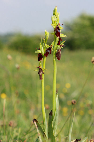
Above: Rare fly orchids can sometimes be found on old lead mining sites.
© Mat & Niki Adlam-Stiles, 2010
|
|
|
|
|
|
|
|