
 |
Like our website?
'Like' us on Facebook... |
|
|
Have you found this site useful? If so,
why not make a small contribution to our running costs. Just click
on the button below for more details:
|
Walking in the Peak District, Derbyshire, UK - Higger Tor and
Padley Gorge |
A medium length circular walk in Derbyshire's Dark Peak moorlands.
Grade: |
Moderate |
Distance: |
11km |
Altitude Gained: |
250m - 300m |
Duration: |
3+ hours |
The rugged gritstone uplands of the Dark Peak contrast strongly with the green
rolling pastures of the White Peak. The heathery moorlands with their
craggy outcrops are equal in beauty, yet very different in character.
Above the small town of Hathersage lies Hathersage moor, enclosed by Burbage
rocks, and punctuated by Higger Tor and Carl Wark. This circular walk
combines the open Hathersage moor, with the delightful babbling brook and wooded valley
that is Padley Gorge.
|
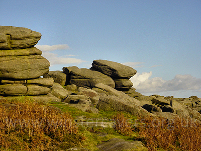
Above: Gritstone outcrops at Higger Tor near Hathersage, Derbyshire.
© Mat & Niki Adlam-Stiles, 2010
|
Walk in brief:
An easy to moderate circular walk with immense variety. There is one steep
section near the start, but otherwise the walk is without major difficulty.
Some of the trails can be rather muddy in wet weather, but in the main clear
paths are followed.
The walk starts near Grindleford station at SK251787. There
is a mix of on-road and paid parking - usually sufficient. There is a cafe
for refreshments near the station, and the nearby town of Hathersage sports a
variety of cafes and outdoor shops.
There is ample scope for extending, or shortening the walk - refer to the
Ordnance Survey Maps OL1 and OL24 for more ideas (irritatingly, you need
both maps).
|
|
|
|
|
|
Starting from Grindleford Station:
We start out on the lane across the railway bridge, then across the river
and past the mill cottages.
A few yards further on, a track on the right heads up hill, and whilst the main
public footpath head right a few yards further along the service road, you may
find navigation easier by ascending the track.
A short distance past the last house on the left, two track heads left (west).
Take the second of these (SK251791) which passes a pumping station and soon
regains the main footpath at SK249792. From here, head North, through the
disused Bolehill quarry, to pick up the old quarry road.
|
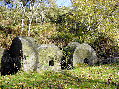
Above: Abandoned millstones at Lawrence Field, near Hathersage, Dark
Peak
© Mat & Niki Adlam-Stiles, 2010
|
As you contour along through a mass of young silver birch trees, evidence of the
old quarrying is all around - and at the further reaches, rock climbers will
likely be enjoying the gritstone faces. Lying amongst the bracken you will
see a multitude of old millstones that never found their way into use.
Heading through the woods there is a multitude of paths and tracks, and staying
on course can be tricky! A GPS can be handy just to verify that, after
~1km, you have emerged from the woods where you expected to - hopefully at the
A6187 Hathersage road, grid reference SK247802.
On the opposite side of the road is Millstone quarry. Three tracks run
parallel through the old workings. My preference is to wlak back along the
road for a short while and take the most eastern of the tracks (SK248800) as
this runs closest to the quarry face, but ultimately all of the tracks merge
after a little more than 0.5km
|
To Cark Wark and Higger Tor:
From the Northern end of Millstone quarry, the track swings briefly East, then
contours North to a junction by a Sheepfold. Head right (East) with the
sheepfold to your right. 0.5km later you will the reach the gritstone tor
of Carl Wark - with some entertaining bouldering problems should you feel the
need.
From Carl Wark there are fine views across the moors, and over to the Hope
Valley. A path runs from the North West corner of the tor, taking you
direct to Higger Tor. At the Tor, keep just slightly East of North,
contouring and keeping the road to your left until you reach Upper Burbage
bridge at SK261830.
Turn right along the road for 100m, before taking the path on the right
Southwards. Again, you have a choice of paths - a track that follows Burbage
rocks at their base, or one that runs along the top of the gritstone
escarpment. Both routes are commendable, and ultimately converge at
the A6187 Hathersage road just East of Burbage bridge, SK263805
|
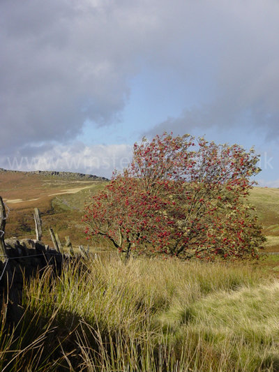
Above: Looking across the windswept Dark Peak moor towards Stanage
Edge.
© Mat & Niki Adlam-Stiles, 2010
|
Descent through Padly Gorge:
A short section of walking on-road can be avoided by taking the path on the
opposite side of the road, and turning right after a few yards, doubling back
towards Burbage bridge. As you approach Burbage bridge and intersect the main
track, a left turn will take you across a small footbridge to follow the stream.
About .75km downstream you pass a junction and a foot bridge - contine to follow
the stream down-dip, and you will soon enter the delightful wooded gorge.
|
|
|
As seems to be a common theme with this walk, there are numerous options for the
return. Following the stream down-stream, and always keeping it to your
right is perhaps the favoured option, and will bring you out at the head of the
lane on which you started your outward bound journey.
For more variety, you may choose to cross the river at either of the two main
crossing points (SK254794 or SK252792) and return via Yarncliff wood - the
latter of the two crossings drops steeply to the river, then climbs. Both
of these paths emerge on the B6521 - turn right and after a few yards
walking on road a short path drops steeply down through the woods to return to
Grindleford Station.
|
|
|
|
|
|
|