Walking in the Lake District, UK - Watendlath from Rostwaite |
A short lower-level circular walk full of surprises
| Grade: |
Easy/moderate |
| Distance: |
8km |
| Altitude Gained: |
~500m |
| Duration: |
3 hours |
There can be few walks in the Lake District that take in such a wide variety of terrain in such a short space.
This circular walk from Rosthwaite is easy to negotiate and enjoyable throughout but could be wet in places.
|
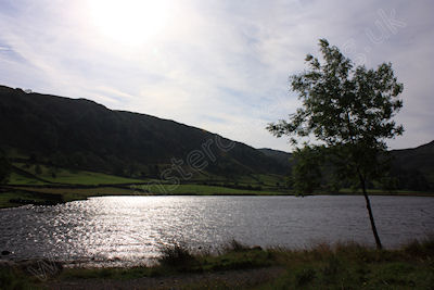
Above: Looking over Watendlath Tarn, Borrowdale - September 2012
© Mat & Niki Adlam-Stiles, 2012
|
Walk in brief:
A short circular walk that encompasses remote open moorland, Lakeland towns, a steep descent through woodland and a riverside stroll.
The ascent is broken into manageable sections-it is only when you descend that you realise how far you have climbed!
An excellent walk the days when the highest peaks are in cloud or when you fancy something slightly more gentle, yet still retaining
the feel of the best of Lakeland hiking.
|
|
|
|
|
The start from Rosthwaite:
The small village of Rosthwaite in Borrowdale as the National trust car park. If there is space, parking in the adjacent village hall car
park will cost you half as much and will directly benefit the village hall.
From the car park walk back to the main Keswick to Hollister Road, turn left and then almost immediately right. Cross the river and take the
track heading left and up. Follow the obvious track uphill, taking time to look back at the ever expanding views of Borrowdale. The track
drops slightly to bring you to the hamlet of Watendlath, with its eponymous Tarn.
|
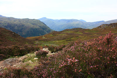
Above: Excellent views of Honisterfrom the col near Dock Tarn,
September 2012
© Mat & Niki Adlam-Stiles, 2012
|
|
Doubling back and right follow the track initially along the side of the time before climbing up into open moorland. The track here can be extremely boggy in places,
but there are well-placed and plentiful steppingstones that seem to avoid you getting muddy feet in all except the very worst of conditions. As one climbs from
Watendlath you reach a junction - take the left hand fork, clearly signed to Dock Tarn. Crossing the moorland the path has a wonderful feel of remoteness to it.
On reaching the beautiful Dock Tarn, keep close to the Waterside until you reach the far end of the tarn. From here follow the path right and up to bring you to a
col between High Crag and White Crag. Here the views over Stonethwaite fell and towards Honister are truly superb.
Return via Stonethwaite
A clear and paved path now drops very steeply down the open hillside and then through plantation to eventually reach the river by Stonethwaite. (A short detour here over
the bridge could bring you to the rather excellent local pub!)
Keeping Stonethwaite Beck on your left hand side follow the obvious path back to the village of Crosthwaite. On meeting the lane by the bridge turn left over the bridge
to return to the main Keswick to Honister Road and to the car park.
|
|
|
|
|