A medium grade walk easily extended along the north ridge of the Valle del Bove
Grade: |
Medium (Strenuous) |
Distance: |
5km (8km) |
Altitude Gained: |
~630m (1110m) |
Duration: |
4 hours (7 hours) |
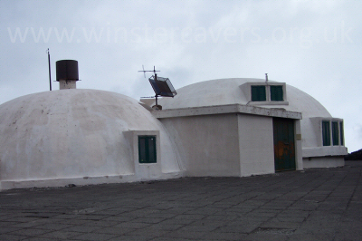
Right: the volcano observatory on Etna Nord, September 2007
© Mat & Niki Adlam-Stiles, 2007
|
|
Walk in brief:
A fine ridge walk along the northern flank of the impressive Valle del Bove, affording
excellent views across the valley, to the summit craters and down to the
sea. Arguably one of the better views of the 2008 "bottoniera" eruption zone.
This medium grade walk with easy way-marked navigation gains a considerable amount of altitude, especially
if extended to reach Pizzi Deneri and the volcano observatory, which makes for a strenuous day's walking
in spectacular terrain.
The approach from Fornazzo:
Follow the signs from Fornazzo for "Etna Nord" (Via Mareneve) and Piano Provenzana and you will soon find yourself on the
long winding road that heads towards Piano Provenzana (the previous cable car station and other main starting point for Etna Nord)
and Rifugio Citelli. The road fell victim to one of the more recent large-scale eruptions and was closed between Citelli and
Provenzana until about 2005.
At an obvious and overly large junction, take the left signposted to Rifugio Citelli and carry on right to the end to the large car park.
At the time of writing, parking was free, and the rifugio could have benefitted from new tiles on the roof!
Etna Nord from Rifugio Citelli:
|
From the cark park, back-track along the road a short distance until a path on the left is seen rising up through the ashy, wooded slopes.
The path is waymarked with red and white paint dots on trees and rocks as it zig-zags its way upwards, passing a curious lava shelter en-route.
After a short while, you break out into a more open area, with an obvious and well travelled route heading upwards and to the right.
Take a note of this point for the return. Our route is straight ahead and upwards, following the paint markers all the way.
|
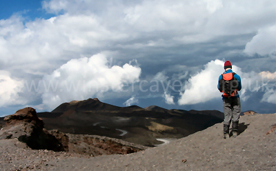
View North West from Etna Nord by the Observatory. © Mat & Niki Adlam-Stiles, 2007
|
The path trends leftwards (South) undulating through wooded slopes, but roughly following a contour. It is waymarked all the way,
although you may have to look carefully for some of the paint markers, especially at a few points where the path crosses old, now
water-worn lava flows.
After a while, you reach the top edge on the 1971 lava flow, clearly identifiable as being more recent lava. It is possible to strike
off straight upwards (WSW) from here leaving the path, but better is to cross the flow, and head steeply upwards at the far side,
again, keep looking for the markers.
After a sharp climb in which you gain some 100m+ of altitude, you'll break out onto the north ridge of the Valle Del Bove. Head upwards
(NW) along the ridge on a well defined path, and enjoy the ridge becoming more pronounced, and the views more spectacular as you gain annother
300m (1000ft) of altitude.
You'll note two old craters in the valley floor, closest is Monte Simone, further away is Monte Centenari. As you climb the ridge, the two
craters will come in-line with each other at the point at which they are almost exactly due South of you. Here, you'll find a small rock
shelter - a great viewpoint and an ideal lunch spot.
The easy option is to make your return from here by following the way markers (sticks with paint on them) across the ashy slops to the head
of the smaller 1973 lava flow. The markers disappear, but keeping to the right of the lava flow as you descend, and bearing right (SE)
as you approach the tree line will bring you back onto known territory, and the descent to Rifugio Citelli.
For the adventurous...(fit!)
The resting point is just below an obvious summit point, climb it if you feel you need the exercise (or want the view) but there is
no need to climb it for the ascent to Pizzi Deneri. Instead, skirt around its base, then stay on the ridge, and keep heading up. And up. And up.
Just in case you can't work out when you've reached the top of Pizzi Deneri, there's a handy cross to help you identify it. From here,
the rather curious Volcano Observatory is a relatively short distance below you, and worth a detour if you have the energy. The route back is to retrace
your footsteps as far as the lunch-stop point and the head down along the 1973 lava flow as described above, although if visibility is
clear it's perfectly possible to shortcut this slightly by heading direct to the 1973 lava when it comes into view.