An easy walk within the Volcanoes National Park
Grade: |
Easy |
Distance: |
8km |
Altitude Gained: |
200m |
Duration: |
3-4 hours |
A slightly extended walk within the Hawaii Volcanoes National Park can be made by combining the
Byron Ledge trail with the Kilauea Iki Trail. Taking in views of the impressive Kilauea
Caldera, and crossing through the very middle of the Kilauea Iki Caldera, this is a
fine walk on good trails of approximately 8km.
The hike can be completed in 1/2 a day without too much difficulty.
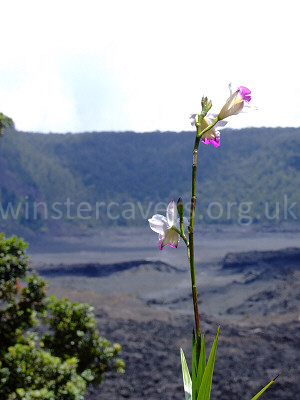
Right: A lone bamboo orchid overlooking the Kilauea Iki Caldera, Hawaii, September 2008
© Mat & Niki Adlam-Stiles, 2008
|
|
Walk in brief:
The Hawaii Volcanoes National Park is dominated by two massive Calderas, Kilauea, and Kilauea Iki. This circular
walk starts at the main Kilauea Visitors Centre, taking in both Calderas and some interconnecting trails.
You're well advised to start by dropping in at the visitors centre. The rangers are extremely helpful, and will
gleefully furnish you with a map of the area - which includes clear details of the trails. Equally important,
they'll update you on the latest volcanic activity in the area, and on which parts of the park are open, or otherwise.
A brief word about the weather
The weather can vary from searing heat, to major tropical downpour! Although easy, the route across the
Kilauea Iki Caldera (about 1 mile) is very exposed with virtually no shelter. You're going to want sun block,
waterproofs, or both! You'd also do well to take plenty of drinking water with you. The park recommend a
2 quarts per person (2 litres) although we found this was more than we really needed.
The approach from Hilo (or Kona):
The Volcanoes National Park is located off of Highway 11 to the South of Hawaii Big Island. Finding it should
present no difficulties, it's clearly signed, and you don't need to worry about 4x4 trails and hire car restrictions.
At the time of writing, entry to the park was $10 USD for a car permit for 1 week. For just a few more dollars,
you can actually buy an annual permit that also covers entry to other sites on the island.
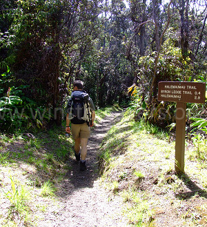
To the Byron Ledge:
|
Opposite the Visitor Centre (across the road) is the famed Volcano House Hotel, on the far
side of which lies one of the main trails skirting much of the crater rim. To the right as
you face towards the caldera, a clearly signed trail drops down through the lushly vegetated
slopes of the caldera. This surprisingly pleasant trail works its way through tree ferns, ohia
trees and ginger plants, bordered by steep lava cliffs.
Simply follow the signs for the Byron Ledge / Halema'uma'u trail, which entails a left turn part way down.
After some very pleasant walking, you'll come to the junction with the Halema'uma'u trail, which
branches off to the right. At the time of writing, the Halema'uma'u trail was off limits due to the
unpredictable nature of the new vent that had opened up in the Halema'uma'u crater. Our route cuts
across the eastern edge of the Kilauea Caldera, following the clearly cairned trail (note that the
route marked by Google Maps is slightly off the real path).
|
Pleasant walking down the trail towards Halema'uma'u, Hawaii.
© Mat & Niki Adlam-Stiles, 2008
|
At the far side, a steep climb gains the "Byron Ledge" which separates the main Kilauea Caldera from Kilauea Iki.
Follow the Byron ledge trail, ignoring the first junction that tempts you back towards the visitor centre. At a
couple of points, the trail passes tantalisingly close to the crater rim, and a minor diversion off the path allows
for a cautious glimpse over the edge.
At the next junction, follow the signs (left) down into the Kilauea Iki Caldera. A steep descent with fine views
across the immense crater.
From here, a clear, cairned path strikes out across the very centre of the caldera, passing various cracks, fractures
and steam vents. You'll likely join the ant-trail of visitors making their way across the caldera on one of the
slightly shorter loops, but despite the lack of solitude, it's worth every moment. At the far side of the caldera,
a steep path zig-zags up to the small car park by the Thurston Lava Cave – a worthwhile detour if you have the time.
On arriving at the car park, head left, and then take the trail on the left – which makes for a more pleasant route
than walking along the road, and head for the larger Kilauea Iki Overlook car park (again, the Google Maps trails is slightly off).
At the top end of the overlook, the trail continues down to the left through the rain forest. Easy navigation (keep right)
will take you onto a section of the old crater rim trail, a dramatic demonstration of subsidence, and your return to the visitor centre.