
 |
Like our website?
'Like' us on Facebook... |
|
|
Have you found this site useful? If so,
why not make a small contribution to our running costs. Just click
on the button below for more details:
|
Walking on Etna - Routes around the summit zone on Etna Sud |
Hiking trails around the South side of Mount Etna's summit (2900m - 3300m).
Grade: |
various |
Distance: |
various |
Altitude Gained: |
up to 400m |
Duration: |
various |
Routes on and around Etna's summit:
Having made your way to the plateau at around 2900m, and assuming you're not in thick cloud, you're going to want to explore a little.
Etna's summit has a peculiar awe-inspiring beauty. She needs treating with respect, but the hiking can be very rewarding.
The area has become something of a free-for-all, with scattered hiking trails in all directions. Described here are a few
suggestions for tours of tops.
|
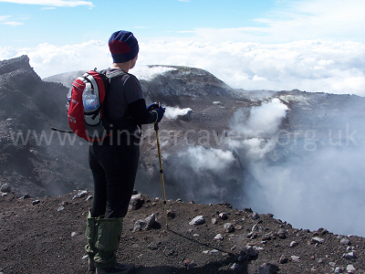
Above: The mighty Bocca Nuova crater, September 2006
© Mat & Niki Adlam-Stiles, 2006 |
|
“No Go” Zones!
Before we describe the summit routes any further, it's only responsible to explain that there are certain areas that are best
avoided. And more to the point, the places that are safe, or otherwise, will depend on the level of volcanic activity at the
time of your visit, on the weather conditions, and your own level of mountain craft. You should note also that, strictly
speaking, it is illegal to climb above 2900m (the altitude of Rifugio Alpino) unless accompanied by a qualified guide. That
said, providing you stick to a few simple guidelines, we have yet to hear of anyone getting into (legal) trouble.
In our humble opinion:
- Do NOT attempt to climb to the top of the South East crater.
- Do NOT attempt to climb down into the major craters of the Bocca Nuova, Nord Est or the Voragine!
- Treat any hornitos with extreme caution. The author (me!) was almost overcome with fumes when he tried to peer down into a recently venting hornito.
- DO check which areas are volcanically active before you go.
- DO be aware that fumes from the craters/fumeroles can be very intoxicating, and possibly injurious to your health.
- DO always be alert. Watch the local area intensely – things can change remarkably quickly! Your main risk is most likely the weather, but it has been known for fractures/vents to open up with very little warning.
And lastly – we are NOT telling you where to go or where not to go, and we are NOT responsible for your actions! Make up your own mind based on the conditions and your level of experience, and if in doubt, consult a fully qualified guide.
|
|
|
|
|
Summit East & “Sud Est” |
Grade: |
Easy |
Distance: |
<1km |
Altitude Gained: |
0m |
Duration: |
n/a |
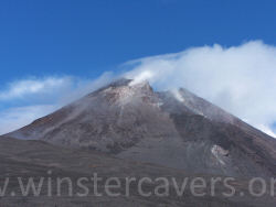
Above: The steaming South East crater at Etna's summit, September 2006
© Mat & Niki Adlam-Stiles, 2006
|
Possibly the most beautiful of the top craters is the South East, aka "Sud Est". Were it not for the recent eruption
at the "Bottoniera", Sud Est and "Nord Est" would be the most active areas on Etna, with eruptions fluctuating between
them. Due care and attention is to be paid when walking in their midst!
As one climbs the jeep track, it takes a distinct left hand bend as it starts to straighten/level out a short distance
before Rifugio Alpino. A stick-and-rope fence sporting a multi-language laminate usually warns unsuspecting tourists
that this is an area of volcanic activity and (not that we'd recommend any such thing) is easily passed to the North,
heading towards the volcano monitoring station previously mentioned. The monitoring station is an ideal spot to observe,
with a little shelter being afforded by the surrounding volcanic bombs. Note the size of some of the volcanic "breadcrust"
bombs, and consider for a moment what the result would be if one were to hit you. Ouch!
From here, it is usually possible to head Northwards along tracks over the fresh lava. Eruptions are frequent in this area,
so it is impossible to say exactly where trails will/won't exist, suffice to say that as soon as it is safe (after an eruption),
the local guides usually start to roughly way-mark and travel a new route. The limit of safe travel is usually, but not always,
marked by some form of stick/rope barrier.
In theory it would be possible to traverse the entire route North towards Pizzi Deneri and the volcanic observatory, but this
is not recommended for two reasons. Firstly, at the time of writing the "Bottoniera" area was quite unsafe, being active and
fracturing, but also, traversing the a’a’ lava flows is remarkably strenuous and slow-going.
Travel to a good vantage point, pause, observe, retrace your footsteps.
|
|
Traverse to Nord Est: |
Grade: |
Moderate |
Distance: |
up to 10km+ |
Altitude Gained: |
~200m |
Duration: |
up to 6 hours+ |
|
If you want to traverse the Summit of Etna as far as the volcano observatory, we'd suggest taking the jeep track from
Rifugio Alpino. The track is clearly defined all the way, and surprisingly few people make the journey.
Not long after you start out on the track, you'll cross some fresh a’a’ flows from a 2006 eruption, when a fracture
opened on the side of the Bocca Nuova with very little warning.
On a clear day you'll get fine views down into Sicily's interior, whilst the Bocca Nuova & North East crater loom over
your right shoulder. It's a reasonable distance, but easy going being on mostly level ground and firm underfoot.
A fine walk is to fully traverse Etna North to South, or vice versa, if you can arrange for transport at the appropriate ends.
|
|
Monte Frumento Supino: |
Grade: |
Easy |
Distance: |
<1km |
Altitude Gained: |
~100m |
Duration: |
<1 hour |
|
If your ascent route hasn't already taken you over Monte Frumento Supino, it's a must. The twin craters rise majestically
above Rifugio Alpino (the little hut for the volcano guides) and usually sports a veritable ant-trail of visitors traversing
the crater rims. The circumnavigation is pretty simple, but worth it. The steaming vent in the Northernmost of the craters
has been plumbed to over 400' in depth.
|
|
The summit of Mount Etna and the Bocca Nuova: |
Grade: |
Moderate-hard |
Distance: |
up to 4km |
Altitude Gained: |
400m |
Duration: |
1- 2 hours |
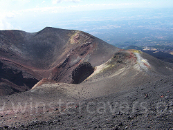
Above: The twin craters by Monte Frumento Supino near the summit of Mount Etna, Sicily, September 2007
© Mat & Niki Adlam-Stiles, 2007
|
Perhaps the highlight of any (non eruptive) hike on Mount Etna is to reach the edge of the Bocca Nuova and the main summit craters.
The Bocca Nuova is a hugely impressive crater, surrounded by fumaroles and steam vents. Climbing to the summit may, or may not be
safe, depending on weather and volcanic conditions.
From Rifugio Alpino it is possible to make a direct ascent by heading for the obvious col between the South East Crater and the
Bocca Nuova. Better, is to make a round trip of the journey by starting out along the jeep track that traverses the West side of
Mount Etna's summit zone.
As the jeep track starts to swing Northwards, and the Bocca Nuova becomes almost due west of you, you'll notice an ashy route
zig-zagging upwards. This is a steep and strenuous climb on soft ground, made even harder by the increasing altitude. It is
not uncommon to see people struggling on the ascent, or giving up.
As you reach the tops, the ground starts to level out, and becomes significantly more compact underfoot. You'll see steaming,
sulphurous fumaroles all around this mystical landscape – fascinating, but potentially hazardous to your health. If at all
possible, stay up-wind of any vent, the fumes can be quite choking, and can hurt your eyes also. Anyone suffering from asthma
or other respiratory ailments should avoid this route. A wise precaution is to take an industrial respirator with you – they
are inexpensive, and remarkably effective.
Traverse along the crater rim anticlockwise (South/East) until the South East crater, fuming away, comes into close view. It
is possible in good conditions to traverse further around to the Voragine, but the volcanic fumes are often very serious, and
this is not necessarily to be recommended. From here, a speedy descent down the col and directly towards the Rifugio Alpino can
be made. A visit to the hornito just North of Rifugio Alpino makes a worthwhile detour.
|
The google map (below) has each of the main routes marked on it, with key way-points also. Zoom in on the map for more detail,
and/or click on any of the routes/way points for further information.
View Larger Map
|
|