
 |
Like our website?
'Like' us on Facebook... |
|
|
Have you found this site useful? If so,
why not make a small contribution to our running costs. Just click
on the button below for more details:
|
Walking on Etna - The Serra del Salifizio ridge |
An exciting ridge walk with fantastic views across the Valle Del Bove, to the summit craters, and the sea far below
Grade: |
Exciting! |
Distance: |
12km (7km) |
Altitude Gained: |
up to 700m |
Duration: |
2 - 5 hours |
Right: The start of the walk, looking up to the saddle at the Serra del Salifizio, September 2010. The ascent route heads up the gully in the
centre of the photo - the ridge climbs from the saddle, to the left.
© Mat & Niki Adlam-Stiles, 2010
|
|
Walk in brief:
The Southern flank of the Valle del Bove has three main features below La Montagnola:
the accessible Monte Zoccolaro at the lower end of the ridge, the lofty Schiena dell'Asino at the higher end, and between them sits the relatively untravelled Serra
del Salifizio. The route from the Zafferana road to the col and view point
presents no serious challenges, with fine rewards for your efforts. Traversing
the full ridge is a far more exciting prospect, with plenty of scope for off-piste
"fun" or navigational challenges.
The approach from Zafferana Etnea:
Follow the signs from Zafferana Etnea for "Etna Sud" and you will soon find yourself on the steeply
ascending SP92 road heading towards Rifugio Sapienza, and the Etna Sud Cable car. Approximately 7km from the last buildings in Zafferana, a parking place and picnic spot on the right is
encountered (Piano del Vescovo).
The walk starts from here.
|
|
The Ascent of the Vallone Degli Zappini, Acqua Rocca to the Serra del Salifizio:
|
|
From the cark park, a tracks heads roughly North, marked as being for residents
only. Don't be tempted to follow this, but instead climb over the stile a few metres
to the left near the start of the track, and head towards the right hand side of the abandoned buildings.
From here, a clearly signed, sandy path will take you up along the Vallone Degli Zappini
- through shady mature beech woods. The path climbs steadily, and easy route-finding will bring you, via a small foot bridge, to the Acqua Rocca - easily identfied by
a small building built over a spring, and the excellent views over towards Catania.
At the Acqua Rocca, a pitch / canyon is bolted for abseiling. You would need
hangers, and to verify the rope lengths required youself!
|
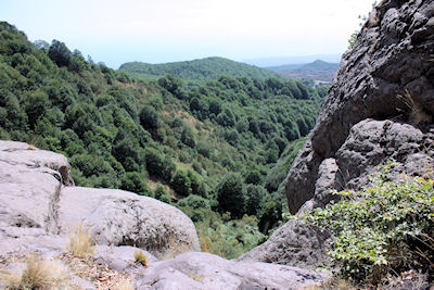
Looking down towards Catania from the Acqua Rocca.
© Mat & Niki Adlam-Stiles, 2010
|
|
From the Acqua Rocca, go past the little building (up) and the sandy path continues to climb, initially staying in
the woods, and later breaking out into slightly more open ground, where the slopes become more ashy, and the going gets a little harder.
Steady progress will bring you to the saddle
that is the Serra del Salifizio, and the rewards for your efforts - outstanding
clear views to the summit craters, down into the Valle del Bove in the North, to Monte Zoccolaro in the East,
down to Catania to the South, and to the West, the continuation of the ridge - all the way to the Schiena dell'Asino and La Montagnola.
If you really want to get
the best of the views, climbing to the viewpoint - the minor summit to the right (East)
- is highly recommended. An easy ascent route can be found to the right
of the rocky promontory, after which the viewpoint is obvious. Care is needed,
as some of the ground is loose, especially near the very summit.
Those who don't fancy tackling the ridge can return
via the same route, having enjoyed an excellent short walk with about 400m of ascent.
NOTE: From the saddle, the 1:25,000 Etna Walking map ("Carta Escursionistica Altomontana")
shows a route descending into, and
crossing, the Valle del Bove. This appears to have fallen into disuse, probably
because recent lava flows have obliterated the routes across the Valle.
|
The Serra del Salifizio Ridge to the Schiena dell'Asino
To the West of the saddle, the ridge rises upwards towards the Schiena dell'Asino.
The
initial climb up the first rocky outcrop is extremely loose - CARE! And there are as many
indistinct routes up it as there have been climbers who have tackled it. The best advice we can give
for the ridge as a whole is to stay high wherever possible.
|
|
As you climb the ridge, you find brief encounters with seemingly well trodden paths, that will
vanish as quickly as they appeared. Route finding is not difficult in clear weather, stay high,
keep the Valle to your right, be mindful of your step, and all should be well! This is not,
however, a particularly popular route. The chances are you'll have the ridge to yourself - with
both the pleasures and seriousness that goes with it.
Just over 1km of exciting scrambling later, and the solar panels and web-cams at the Schiena dell'Asino viewpoint will come into view, and with it comes the end of the main ridge.
|
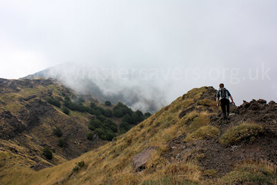
The Serra del Salifizio ridge - stay high, and watch out for loose ground.
© Mat & Niki Adlam-Stiles, 2007
|
Descent via the main Schiena dell'Asino track:
The sensible route to descend from here is via the main track to/from the Schiena dell'Asino viewpoint.
From the webcams, a well trodden path soon appears, and by walking just a few metres westwards beyond the webcam
you'll find a small jeep track on the left. Follow this undulating track (initially Southwards, then trending
Southwest) for ~2km to arrive on the main SP92
Zafferana - Sapienza road some 2.5km as the crow flies from the start point of the walk. Returning along the road isn't great, but several of the switchbacks can be shortcut on foot, and it doesn't
take as long as you might imagine.
|
Direct descent
If you don't like the idea of the long descent by road, and are up for a little "off-piste", the Etna
1:25000 map shows two tracks heading directly down the hill towards Piano del Vescovo.
The one from the Schiena viewpoint follows a broad ridge, entitled the "Uzu saro
a vecchia".
This is yet another track that has fallen into disuse, but from the Schiena webcam it is possible to navigate one's way down by heading initially for the rocky outcrop approximately South East of the webcam. From there,
work your
way down the obvious rib, staying as high as possible, and in the open ground.
You'll note a distinct line in the landscape - dark green oak trees on the left fill the deep gully, whereas
much paler Etna Broom occupies the more open ground. If you look carefully, you'll see the very left-hand tip of the largest of the switchbacks
on the Zafferana-Sapienza road. This is where you're aiming for. Take a bearing, and head down the ridge keeping the oak trees
just to your left. Some unpleasant bush-whacking will bring you to the boundary between the tree types - it's very
clear when you get there, and by keeping on this boundary you'll soon find you were not the first to try this route!
At the end of the rib, the boundary suddenly vanishes, but as it does so, the path
becomes more distinct - dropping
through the woods down to the road. Eventually you'll pop out in a most unlikely place on a switchback, just over 1km from
your start point.
|
View Walking On Mount Etna, Sicily in a larger map
|
|
|