A short walk with fine views across the Valle Del Bove and to the summit craters
Grade: |
Easy |
Distance: |
2km |
Altitude Gained: |
~275m |
Duration: |
~45 minutes (up) |
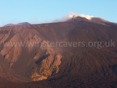
Right: View of Mount Etna's South East crater at sunrise, taken from Monte Zoccolaro, September 2007
© Mat & Niki Adlam-Stiles, 2007
|
|
Walk in brief:
Monte Zoccolaro is a relatively small peak on the southern flank of the impressive Valle del Bove, affording
excellent views across the valley, to the summit craters (especially the South East Crater) and down to the
sea, including Taormina and the southern tip of mainland Italy.
The short, steep walk makes a superb introduction into walking on Etna and has frequently offered a superb vantage
point when the volcanic activity is too strong for safe observation at close quarters .
The approach from Zafferana Etnea:
Follow the signs from Zafferana Etnea for "Etna Sud" and you will soon find yourself on the steeply
ascending road heading towards Rifugio Sapienza, and the Etna Sud Cable car / tourist honey-pot. If in doubt,
and travelling in the summer, just follow the steady flow of tourist-laden coaches that flock towards Sapienza!
You'll soon leave Zafferana, passing the "Emmaus" hotel, and an inconspicuous track on the left to
the Grotte del Gatto (Cat Cave).
As the road twists and turns, it breaks out into the lava fields, and the views start to become more and more
far reaching. After approximately 4.5km from the last buildings in Zafferana, a turning on the right is
encountered just after a left-hand switchback. Take this right - it is easily identified by a barrier a very
short distance down the turning that come across the right hand side of the road only. Drive past the barrier,
and keep going to approximately 3km, until the road comes to an obvious halt with a large turning / parking area.
This is the start (and end) point for the walk.
The Ascent of Monte Zoccolaro:
|
From the cark park, take the obvious forestry track adjacent to the small wooden rifugio heading slightly uphill.
The only real piece of route-finding you need, is to turn right approximately 50 meters along the forestry track,
leaving the main track and taking the obvious footpath that starts to climb steeply through the wooded flanks on Mount Etna.
During the spring months, the route is green and lush, with a fascinating variety of indigenous plants.
|
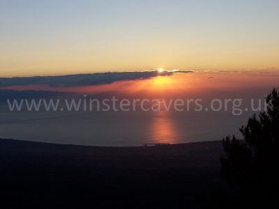
Looking East from Monte Zoccolaro at sunrise. © Mat & Niki Adlam-Stiles, 2007
|
The sandy path is relatively clear all the way to the summit cross as it climbs relentlessly through the woodland.
If in doubt trend upwards/right, but be aware that as you climb, the cliffs to your right become steadily more precipitous!
After about 30 minutes work-out the trees begin to thin, and you reach a small (and not always obvious) plateau on the right.
From here you can gain your first views over the impressive Valle del Bove, but climbing right to the summit will give you
the best views of all.
The summit of Monte Zoccolaro is marked by an obvious cross, and just a few yards past the summit, sheer cliffs drop down
into the Valle Del Bove some 200 meters below. A cautious step down to the left of the cross gives awesome views down into
the valley, whereas the more obvious vista on the right will give a wider panorama. Looking North East, the South East
crater of Etna dominates the skyline, with the Valle Del Bove to the North, and the coast to the West. On a clear day, the
Italian mainland is clearly visible.
The ease of ascent/navigation makes this a fine viewpoint for observing Etna by night (albeit from a distance) and
sunrise viewed from here is quite breathtaking.
Spend a while at the summit, enjoy, observe, then simply retrace your steps. It's easier on the way down!