
 |
Like our website?
'Like' us on Facebook... |
|
|
Have you found this site useful? If so,
why not make a small contribution to our running costs. Just click
on the button below for more details:
|
Walking in North Wales, the UK - Carnedd Llewelwyn, Snowdonia |
A moderate circular walk combining well trodden paths with some more isolated situations.
Grade: |
Moderate |
Distance: |
16km |
Altitude Gained: |
950m |
Duration: |
5 - 6 hours |
North Wales sports some of Britain's finest walking routes, and when the weather
is fine, hikers of all ages flock to the hills to enjoy the superb routes up the
Glyders, Tryfan and, of course, the famous Snowdon with its multitude of
excellent trails.
And yet just a few miles away lies the relatively overlooked Carnedd Llewelyn -
a lesser mountain by a mere 20m, and a worthy prospect for a day out.
|
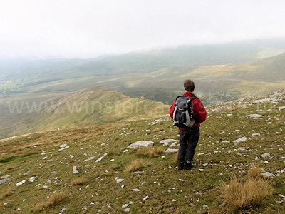
Above: Looking along Mynydd Du from Carnedd Dafydd on a misty day -
August 2010
© Mat & Niki Adlam-Stiles, 2010
|
Walk in brief:
From the lively little town of Bethesda, the horseshoe of Carnedd Llewelyn
/ Carnedd Dafydd is
hard to miss. Rather than take the popular routes from, for instance, Pont
Pen-y-benglog / Idwal Cottage, this circular walk starts in Bethesda . It
combines some lesser travelled paths with some of the main summit route,
followed by a fine off-piste descent route down the Mynydd Du ridge, before
returning to Bethesda.
Despite the 950m altitude gain, the walk is not too serious an undertaking,
with the pull up to Bera Bach being by far the most strenuous part of the walk.
Bethesda itself has plenty of places to stop for refreshments, should you feel
the need to fuel up before the walk, or recover afterwards.
The walk is covered by the 1:25,000 Ordnance Survey map OL17 (Snowdon/Yr Wyddfa)
|
|
|
|
|
The start from Bethesda:
Our walk starts from the town of Bethesda.
Whilst it is possible to start in the town centre, you may prefer to take the
small lane to Gerlan. Parking is limited and some of it is residents only
(please don't try driving to the very end of the lane, and park considerately)
but there's usually enough space to be found.
Our walk then starts in earnest by heading up the Ciltwllan lane, the foot
of which is where the houses finish at SH633663
|
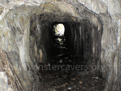
Above: The short mine level on the ascent route of Carnedd Llewelyn,
August 2010
© Mat & Niki Adlam-Stiles, 2010
|
The lane climbs uneventfully at first, leaving behind the somewhat grey
backwaters of Bethesda, before picking up an old miners'/quarrymen's track at
~SH639665. Right here soon starts to take you into the valley, the track
following the Afon Caseg river upstream. 2.5km of easy walking takes you
deep into the valley, with two notable features on-route.
At ~SH652667 the path crosses a short trial mine level. Easily spotted by
the open-cut just to the left of the track, it is possible to make a brief
detour by dropping down to the right, and entering the mine level there.
You barely need a torch, although having one with you may just save you getting
wet feet.
Further up the valley and just above the main track lies an old settlement (SH
657669), also worthy of a detour.
|
Climbing to Bera Bach:
Beyond the settlement, the track starts to degenerate, becoming progressively
more boggy underfoot as it swings round to hug the Afon Caseg river before
completely petering out.
Just beyond the settlement look up and to your left, and you will see the rocky
promontory of Bera Bach. Rather than follow the low route, we strike off
NE heading direct for the minor peak. There is no path at this point, but
the land is access land, and by heading direct for the peak of Bera Nach,
navigation is easy.
|
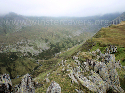
Looking towards Carnedd Llewelyn - the tops of which are in cloud! August
2010.
© Mat & Niki Adlam-Stiles, 2010
|
|
As you approach the rocky outcrop (some distance short of the summit), you will
intersect a clear footpath running roughly NW-SE (SH672675). Keeping
right here, then right at the next junction will climb more gently towards the
peak of Gernedd Uchaf before skirting around its Southern flank. A short
distance further on and you will hit the broad and well-trodden track taking you
over Foel Grach (976m) and bringing you onto the broad ridge that takes you to
the summit of Wale's second highest mountain, Carnedd Llewelyn - a
respectable 1064m high.
On a clear day, expect far reaching views - and quite a lot of other walkers.
In the mist (which is common!) the view vanish and summit has a more mysterious
feel, perhaps less grandiose, but pleasant nonetheless.
From the summit of Carnedd Llewwlyn easy walking along the broad track heads
south, before swinging Westwards along the craggy tops of Cefn Ysgolion
Duon to the cairn at the only-slightly-lesser summit of Carnedd Dafydd - 1044m ,
SH663631.
From the summit cairn of Carnedd Dafydd, the main track heads SSW down to Idwal
Cottage and away from our starting point. Rather than following the main
track we instead head North West, then North, and carefully keeping the
precipitous crags on our right, descend to pick up the unofficial path that has
developed along the small ridge of Mynydd Du. From here, easy walking will
drop you onto the lower path near the riverside. Follow this North West
for ~ 1km, past the waterworks and you will pick up the far end of the Gwernydd
/ Gerlan road, and return to our starting point.
|
|
|
|
|
|