
 |
Like our website?
'Like' us on Facebook... |
|
|
Have you found this site useful? If so,
why not make a small contribution to our running costs. Just click
on the button below for more details:
|
Walking in North Wales, the UK - from Idwal to Capel Curig, via Glyder Fawr and Glyder Fach |
A medium length linear walk on clear paths.
Grade: |
Moderate ~ hard |
Distance: |
13km |
Altitude Gained: |
~850m |
Duration: |
5 - 6 hours |
This excellent linear walk combines the ever popular traverse over the Glyders
with the less visited long, broad ridge dropping down into Capel Curig, taking
in excellent views over Tryfan en-route.
Once the ascent of Glyder Fawr is accomplished, much of the walk is on
undulating ground, with some entertaining short scrambles for those who want
them.
|
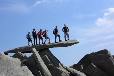
Above: A group on the famous "Cantilever Stone", Glyder Fach
© Mat & Niki Adlam-Stiles, 2011
|
Walk in brief:
From the Youth Hostel at Idwal Cottage, a steep track provide access to the
popular Idwal Slabs rock climbing area, and to Glyders Fawr and Fach - often
done as a circular walk. We left a vehicle at Capel Curig and got a lift to
Idwal to allow us to do a linear walk. The bus route from Betwys y Coed to
Bethesda stops at Capel Curig also.
The walk has a ~850m altitude gain, most of which is done in the initial ascent
up the "Devil's Kitchen" route to the summit of Glyder Fawr. From here,
the route is mostly level, undulating no more than 100m between summits.
Refreshments
are available at either end of the walk - there are cafes at both
Idwal and Capel Curig. The walk is covered by the 1:25,000 Ordnance Survey map OL17 (Snowdon/Yr Wyddfa)
|
|
|
|
|
The start from Idwal Cottage:
Facing Idwal Cottage (SH650603), an obvious path on the left
climbs steadily towards the lake of Llyn Idwal. As you approach the lake,
the path forks to run either side of Llyn Idwal. Either route is possible
- they meet again at the foot of the Devil's Kitchen Ascent - our preference was
to take the right fork, crossing the foot bridge and taking the path the far
side of the lake, thus getting the wider views of Idwal Slabs, and the benefit
of the morning sun.
As you draw level with the far end of Llyn Idwal, the path starts to climb more
steeply, heading into the gulley.
|
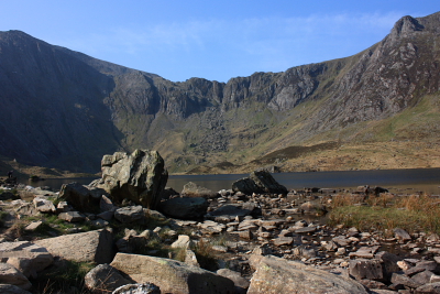
Above: Looking across Llyn Idwal towards the Devil's Kitchen ascent
© Mat & Niki Adlam-Stiles, 2011
|
As is often the case, a path skirts around the very peaks (to the South of the
summit) - our preference was to stay high. Heading almost due East, a
short descent from the very tops gains a more distinct path heading directly for
the other main summit of the day, Glyder Fach.
Again, the summit can be bypassed by a slightly lower level path - but if you're
up for a bit of scrambling, the very summit of Glyder Fach (994m) is well worth
the extra effort. Climbing down from the craggy summit, you soon reach the
Cantilever Stone - climb on top of this gravity defying slab for an unmissable
photo opportunity!
|
| Descending toward Capel Curig:
From the Cantilever Stone, continue Eastwards on an increasingly clear and broad
path, passing the main paths onto Tryfan on the left, to descend to the col and
a crossing path (The miners' track) at SH667583, shortly before the small lake
of Llyn Caseg-fraith. From here, you are unlikely to see many fellow walkers.
Keep straight ahead, keeping the lake on your left. Throughout the whole
of this section, excellent far-reaching views are to be had, with neighbouring
Tryfan dominating the skyline.
|
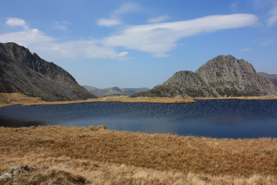
Looking towards Tryfan from Llyn Caseg-fraith
© Mat & Niki Adlam-Stiles, 2011
|
|
Continuing East, climb gently on more boggy ground to the lesser summit of Y
Foel Goch (SH673582), and the un-named summit above Gallt yr Ogof (SH685586)
before starting the long descent to Capel Curig. From here, you will see
the path descending alongside a dry-stone wall, and then over a stile.
Route-finding from here is now easy - just follow the path along the broad ridge
that descends gently Eastwards, ignoring two paths on the right.
Approximately 2km after the stile, the path starts to descend more steeply, and
can be slippery (care), to bring you down to a small track near a farm.
Left here soon gains a larger track, where a right turn down hill brings you
to the car parking and cafe at Capel Curig.
|
|
|
|
|
|