A moderate walk made harder by the altitude
Grade: |
Strenuous |
Distance: |
10km (16km) |
Altitude Gained: |
~600m (800m) |
Duration: |
4 hours (6 hours) |
At first glance, Mauna Loa looks neither high, difficult, or inspiring, but
the trek across the lava flows has much to commend it and is harder than one might
expect. When clear, the views
from the top and the upper caldera are truly stunning.
Right: The long mound of Mauna Loa as seen from Pu'u Huluhulu, September 2008
© Mat & Niki Adlam-Stiles, 2008
|
|
Walk in brief:
The full ascent of Mauna Loa from the South is a 4 day hike, gaining some 3000+m
of altitude. But from the north, it is possible to drive as far as the weather
observatory at 3400m, and hike from there - an altogether more manageable walk that
makes topping out in a day a real possibility. But
the hike has its own challenges, not least of which is the potential lack of acclimatisation
to altitude - the summit of Mauna Loa is not far short of 4200m.
Handling the Altitude:
Before we headed off, we'd read much hype about the effects of altitude - sufficient
to make us cautious of the ascent. Headaches, breathlessness and nausea are
amongst the main "symptoms" you can expect, but we found that as long as we trod
carefully, the ascent could be made without problems. Popping a couple of
ibuprofen before heading off seems to help, and drinking plenty of water is a must
- little, but often. One guide book we read recommended stopping off at Pu'u
Huluhulu for an hour or so before heading up - worthwhile in its own right, it's
a jolly little hill.
Above all though, just pace yourself. Walking at a steady, sustainable pace
made the ascent a pleasure, rather than an ordeal.
The approach from Hilo (or Kona):
From whichever side of the island you're starting from, you need to get yourself onto highway 200
- the infamous "Saddle Road". The tales of this being a crazy
road only fit for 4x4 vehicles seems to be somewhat out of date - from the Hilo
side at least, the character has been stripped from the road, and replaced with a
serious amount of silky-smooth tarmac. The car hire companies may insist you need
a 4x4, but that would appear to just be a useful way of pulling in a few extra dollars!
At the saddle, approximately 1/2 way along the Saddle Road, you'll find a crossroads.
The newly made-up road to the North takes you up to the summit of Mauna Kea.
To the South though, a smaller rougher track will take you up to the weather obversatory
on the North flank of Mauna Loa. Although branded as a 4x4 only track, it's
actually pretty solid - and, weather permitting, careful progress with a standard
motor should get you
to the weather station without difficulties.
As you approach the weather station, there's an obvious small carpark / layby on
the left with space for 3 or 4 cars. The track continues beyond, but progress
with anything less than a serious 4x4 would be somewhere between unwise, impossible,
and downright stupid!
Mauna Loa Summit from the North:
|
From the cark park, head out along the continuation of the jeep track - you'll soon realise why
we say not to take your (hire) car along it! The track zig-zags for some considerable
distance to reach one of the main way-points for the summit trek, but rather than
follow the 4x4 track, after just a few minutes walking, look
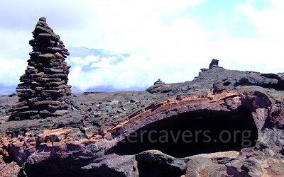
out for the cairned trail
that breaks out on the left and strikes out across the lava field.
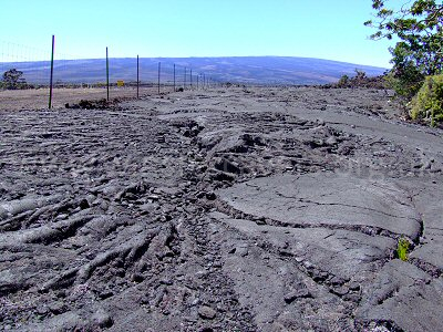
Steadily progress along the trail, following the cairns across the lava field.
Navigation is easy in good walking conditions, but at night or in poor visibility,
spotting the next cairn could easily present a challenge.
|
View of the cairned hiking trail heading to the summit of Mauna Loa, Hawaii.
© Mat & Niki Adlam-Stiles, 2008
|
After about a mile, you'll reach, and cross, the jeep track - at the time of writing, simple
wooden signs point the way to the Mauna Loa Summit. Continue upwards through the lava fields noting the many "bubbles", indicative of the shield nature of the
volcano, until you reach the jeep track once more. The route now continues
upwards (it's ALL uphill!) until you reach the end of the jeep track, and a polite
notice pointing out the need for a back country permit for overnight camping.
From here, the trail takes on a somewhat more appealing aspect, as one climbs steeply along an ashy path,
bordered with fractures from the eruption of Mauna Loa in 1984.
You'll probably start to notice the altitude too, but from here to the summit caldera
isn't too far. Losing the ashy path and crossing more cindery lava
flows, still following the line of cairns, a sort of junction is reached, with a
left turn taking you to the "luxurious" pit toilet - a unique experience to say
the least!
Skirt around the left of the pit toilet, and 10-15 minutes more hiking will bring
you to the breathtaking summit caldera - but not the summit! You'll be pleased
to know, however, that you've managed to hike to the 4000m mark...
Unsure of what effects we'd really encounter with the altitude, and having made
a later-than-ideal start, our plan was to lunch at the caldera, and then retrace our steps -
but the summit is another 200m of ascent from here for those who fancy
it.
Progress down seemed to take
no time at all, and one can bound down the hillside
with remarkable ease, taking in deep breaths of ever richer, pure mountain air.
A worthwhile excursion, worthy of the effort, and best enjoyed from an early start.
Heading to the summit
From our lunch spot, a line of cairns can be seen skirting the north
side of the crater rim and heading towards the summit - for us this was something for another day,
but the route looked well worthwhile, eventually gaining a vantage point high
up above the caldera.
Of equal interest is the
clear route towards the Southern side of the caldera, which
makes its way towards the mountain hut, and the more traditional ascent/descent route.
We've watched the sunset from Mauna Kea - it was stunning. The
sunrise over Mauna
Loa is reportedly just as magnificent, and a key reason for staying
at the mountain hut.