A short walk with fine views across the Valle Del Bove and to the summit craters,
easily extended to produce an all-day trek on some of Etna's finest terrain
Grade: |
Easy (hard option) |
Distance: |
3km + |
Altitude Gained: |
~360m (up to 800+m) |
Duration: |
2 hours (up to 6 hours) |
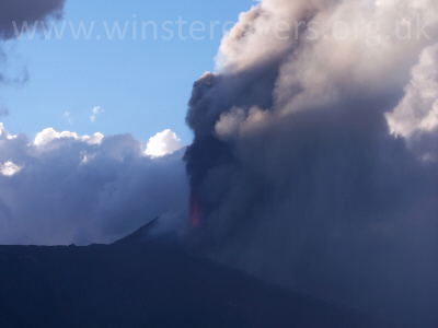
Right: View of Mount Etna's South East crater in eruption, taken from Monte Zoccolaro, September 2007
© Mat & Niki Adlam-Stiles, 2007
|
|
Walk in brief:
Whilst the ascent of Monte Zoccolaro provides a fine and trusty viewpoint, it perhaps lacks
in two areas. Firstly, the summit is actually some considerable distance from
the top craters (~6.5km) and secondly, the logical return route is for one to retrace
their footsteps.
The Schiena Dell Asino (which loosely translates as the "Ass's back") does not suffer
these minor shortcomings. The ascent is again on clear paths with only minor navigation
required, the views are superb, and the main viewpoints are appromimately 1/2 the
distance to the top craters. An out-and-back walk to the Schiena is an easy
undertaking - but this can be readily augmented by trekking along the Schiena ridge
up to La Montagnola, and returning via the magnificent Silvestri Craters.
The approach from Zafferana Etnea:
As per the approach for the Monte Zoccolaro walk, follow the signs from Zafferana Etnea for
"Etna Sud" and head out on the steeply ascending road to Rifugio Sapienza,
and the Etna Sud Cable car. There is just one turning on the
left hand side dropping down towards Nicolosi about 1km before Sapienza. Directly
oposite this turning is a small pull-in, large enough for a small number of cars
- watch your exhaust pipe when pulling off the road!!
This is the start point for the walk. If there is insufficient parking here, there is a larger layby
on the right just a short distance further uphill.
The trek to the Schiena Dell Asino:
|
At the Eastern end of the pull-in is a gated foresty track heading uphill through the pine woods.
Take this track and ascend steeply, via a couple of switch-backs until you eventually break clear of the tree line.
On a clear day, you will get magnificent views all the way down Catania and the Sicilian Coast.
The route now changes in character as a smaller, but still well-defined track works its way less steeply through
the ashy slopes. Somewhat barren at the end of a hot summer, in spring these slopes sport a vibrant abundance of
flowers - in particular mountain pansies fill the area with pastel shades.
|
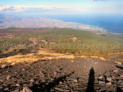
Looking down to the Sicilian Coast from Mount Etna - June 2008. © Mat & Niki Adlam-Stiles, 2008
|
After ~30 minutes, a gully is crossed, with clear evidence of people trekking "off piste". A detour to the left
will bring you to the "Grotte di Pitagora" lava cave. The main route contours the gully, dropping gently
until a more solid lava flow can be seen just below. Here the path swings more nothwards towards the Schiena,
intersecting a more major path. The junction here is marked with a small cairn. NOTE THIS POINT if you
intend to return by the same route, as the junction is easily missed.
Very shortly after this, a more confusing junction is reached. The large jeep track dropping slightly to the
right will bring you out on the Schiena at a lower altitude, but better is to take the middle (just right of straight ahead)
path that heads directly for the ridge. As you approach the ridge, you note an abudance of high-tech gadgets to
the right of the path. This is one of the INGV volcano monitoring stations, including the Schiena webcam.
From the Schiena you get a magnificent and far reaching panorama. It the weather is borderline, there are two good,
sheltered vantage points just over the edge of the ridge - the better of which is located by the junction where the path
you approached by intersects the vague path running along the ridge. CARE as you step off the path!!!
The simple and short return is to retrace one's footsteps, but a fine extension to the walk is to strike off up the ridge
to reach the base of La Montagnola. This route becomes harder going as the path degenerates into ashy slopes, but the view
over the Silvestri Craters from La Montagnola makes it all worthwhile.